We're spending a soggy day at Northern Outdoors near Caratunk, ME, riding out the hurricane. Three days ago, we stopped for lunch on the roadside near Stratton, when our friends Swift, Deja, and Who Knows appeared and informed us of the impending landfall of Irene. The stretch between Stratton and Caratunk is either above treeline or boggy areas along ponds. Not good when the forecast calls for significant rainfall and high winds. So the five of us decided to push to Caratunk by Saturday night, in advance of Irene's predicted Sunday arrival.
One small hitch: crossing the Kennebec. All of the AT guidebooks stress the need to take the ferry across the river and the danger of fording it. The dam upstream releases unpredictably, which means the water levels can rise dramatically and quickly. Several hikers have died attempting the crossing, so now, the official AT route is the ferry.
Now, you need to keep in mind that when I say "ferry," I'm not talking about Staten Island. I'm talking about a guy and a canoe. Hillbilly Dave takes you two at a time across. And we witnessed firsthand the issues with the Kennebec. It was pretty innocuous when Pancho and I went across. By the time our buddies came across, the water had come up more than a foot and the current picked up enough to make it difficult to land the canoe. The ferry only operates two hours each morning and afternoon, so making it in time for the ferry was an issue. On the heels of two long days, we busted out thirteen miles over relatively flat terrain to get to the river crossing. By the last three miles, we were exhausted, driven only by the promise of hot showers and reputedly awesome nachos.
So now, we're waiting on a weather window to head out for our last 150 miles. Hopefully, we'll leave here tomorrow, but at the moment, we're drinking some great microbrews, playing Ms. Pacman, and listening to lots of 80s tunes.
We'll keep y'all posted. Hope everyone in the storm zone stays safe and well.
Sunday, August 28, 2011
Monday, August 22, 2011
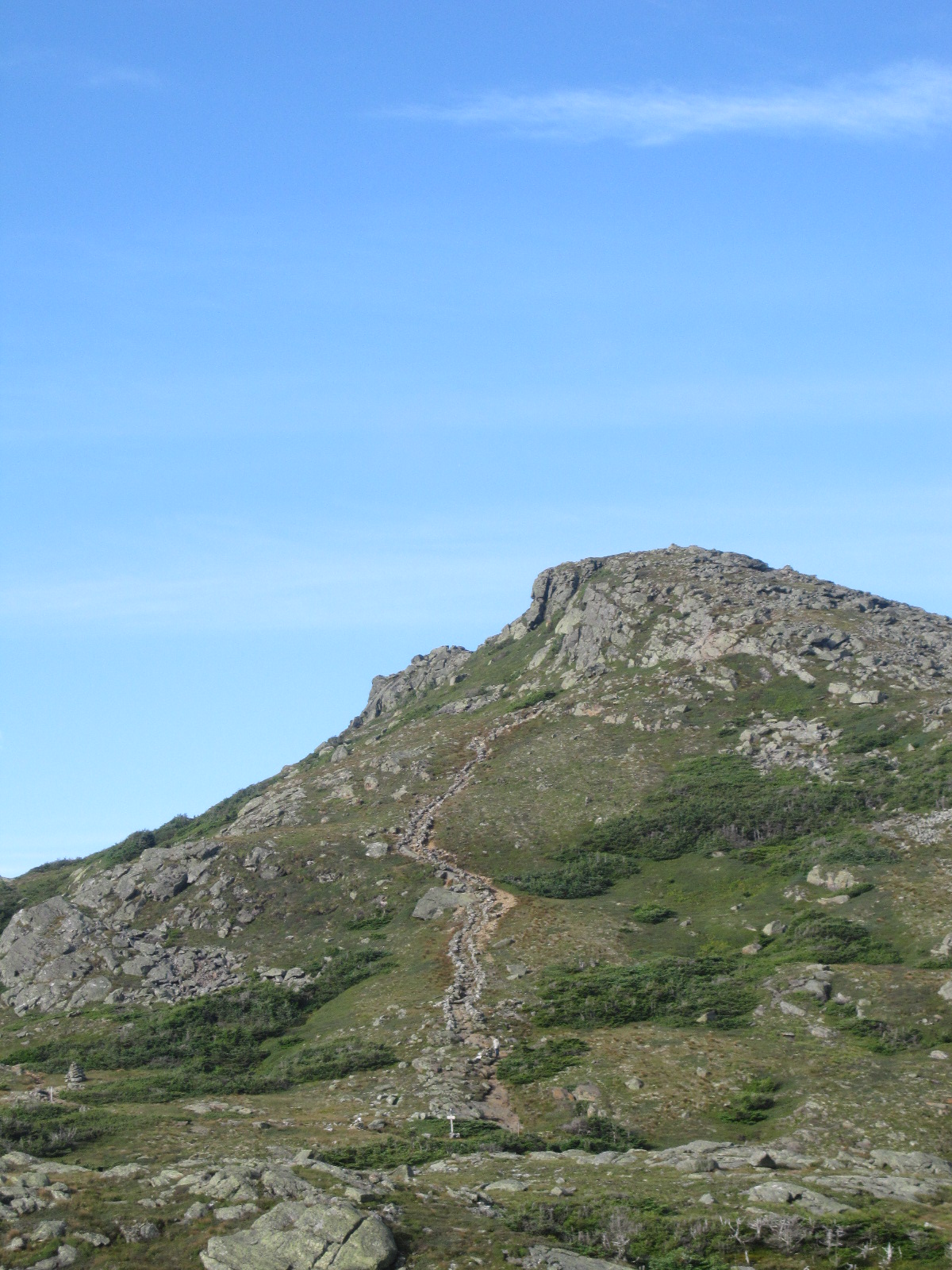
Entering Maine, as Tough as the Whites, plus Bogs
 |
| Welcome to Maine! |
The Whites may have the reputation for being the toughest section of the AT, but southern Maine is sure as hell no cakewalk. We headed out of Gorham in the rain, on a slippy, sloppy trail. Probably the dominant feature in Maine is the mud, in some cases, bottomless pools crisscrossed with wood planks. These “bog-boards” may—or may not—actually be above the surface of the mud or water. A misstep can land you thigh or hip deep in the muck, and you’re unlikely to ever see your boots again. There are also near-vertical scrambles up rock faces, which really aren’t that pleasant in the rain, when you never know, if your feet will shoot out from under you and send you reeling back to the bottom.
 |
| The first view of Maine, after a foggy first day. |
Our second day in Maine was clear and sunny, but it also took us into Mahoosuc Notch, notorious as either the most fun or most difficult single mile on the trail. We would have to vote for the latter. It’s not so much hiking as it is an exercise in creative problem-solving in three dimensions. It’s difficult to describe the Notch to the uninitiated—it’s a scramble over, under, through rocks of all sizes. And it took us FOUR hours. Did I mention that it’s just ONE mile? Oy. Part of the problem for us was the scary, nasty fall Pancho took near the beginning of the Notch. He lost his footing, and fell straight back, 5-6 feet down, flat onto his back. It was one of the rare moments that having a huge pack strapped to your back became a positive. His ankle wedged between two rocks, twisted, yet, fortunately not broken. It scared the crap out of me.
After a long, frustrating day on the trail, we reconnected with our friends Swift and Deja, before heading into Grafton Notch and the Mahoosuc Mountain Lodge. Not one of our better choices. A great facility—they guide dogsled trips and have 40 huge dogs on site—but not as hiker-friendly as they could be. So, our intrepid buddy Swift set out to hitch 15 miles into Bethel for supplies (i.e., beer and food). If there is one guarantee with Swift, it’s that he’ll come back with a great story. It took 2 hitches to get into Bethel to the grocery store. Swift left the store with a shopping cart full of burger-fixings and beer. After pushing the cart for some distance, he spied a pizza delivery shop. Huh. An opportunity, no? So he went in and asked if they delivered to the Lodge. Nope—too far. “Really?” says Swift. “Well, let me talk to the driver.” “What do you mean?” sputters the manager. “That’s not how this works!” But Swift already had the driver in his sights and says, “let’s talk terms….” After a bit of negotiating and an exchange of currency, Swift, the driver, two pizzas, the groceries, and beer are on the way. Soon thereafter, Deja and I spot a car gliding to a stop in the drive, about 100 yards from the Lodge. Excitement—it’s a pizza guy! And Swift! Why are they stopped way out there? Because, they ran out of gas, of course. But we had appetizer pizza, burgers on the grill, and beer. Not such a bad evening J.
From Mahoosuc Mountain, we headed into Andover to the Pine Ellis hostel. To say that Andover is a small town is a bit of an understatement. There are two hiker hostels, a general store/gas station/diner, and one stop sign. We stayed at the “better” of the two hostels, as we got to sleep in a room with a bed versus sleeping in the driveway in a cargo container (no joke!). We spent three nights there, slackpacking through the difficult section of southern Maine. Though very tasty, we definitely exhausted the menu at the diner, not to mention freaking out the waitresses with the sheer quantity of items we ordered at every meal.
 |
| On top of Baldpate Mountain. |
 |
| Pancho in Maine. |
 |
| With Swift and Deja at Pine Ellis, Andover, ME. |
This morning, we finally left Pine Ellis, heading into Rangeley, an adorable vacation town on a string of beautiful lakes. We busted out a blazing 13-mile hike in under 6 hours, then hitched into town to the North Country B & B, in a beautiful old house facing the lake. At the moment, we’re sitting at the bar of a little bistro—a delightful change from the Andover diner—drinking some wonderful blueberry-basil cocktails (Pancho is paying attention so he can re-create at home).
This will likely be our last post with pictures until we summit Katahdin. We only have 14 hiking days left on our northbound leg. Wow. We’re planning to take a break for a couple of days near Caratunk, after crossing the Kennebec (in a canoe ferry!), at Northern Outdoors center, for some rafting and beer, to fortify ourselves for the last push.
Sunday, August 14, 2011
White Mountains--been there, hiked that.
We rolled back into Gorham yesterday afternoon after knocking out the last 22 miles of the Whites, including a tough climb up the numerous, unending slopes of Wildcat. Though it's a rather unheralded section of the Whites, not being on the way to Mt. Washington, there were still the White Mountain hallmarks--steep ascents and treacherous descents. Fortunately, by the time we reached the last, nasty downhill into Imp campsite, we had perfected our sit-and-scoot technique for descending sheer rock faces. Otherwise, we were going down like second-rate Tarzan impersonators, desperately clinging to the scrawny pines clinging just as desperately to the mountainside. After a frigid, windy night at Imp, we headed back toward town, finishing off with a refreshingly benign hike along the beautiful Rattle River. We spent another delightful evening at the bar at the Saalt Pub here in Gorham and now we're back at McDonald's, availing ourselves of the Wifi.
16 miles to the Maine border, and the last state in the northbound leg of our hike. It's actually a bit odd and anticlimatic, for us, at least. Now, when we chat with folks on the trail and say that we're northbound thru-hikers, they congratulate us and say how exciting it is to be this close. And of course, most of the other hikers we know are almost done. Their last state, counting down the miles to that big moment on top of Katahdin. It will be awesome to witness and share that experience with some of our new friends, even though we'll have several hundred more miles to complete our own journey. Yet, as one of our buddies pointed out, we'll have two summit experiences, and one of them will be at home.
 |
| Pond approaching Carter Notch Hut. |
 |
| Looking back down on Carter Notch Hut, a small assembly of buildings near the lower left. |
 |
| View from Mt. Moriah. |
16 miles to the Maine border, and the last state in the northbound leg of our hike. It's actually a bit odd and anticlimatic, for us, at least. Now, when we chat with folks on the trail and say that we're northbound thru-hikers, they congratulate us and say how exciting it is to be this close. And of course, most of the other hikers we know are almost done. Their last state, counting down the miles to that big moment on top of Katahdin. It will be awesome to witness and share that experience with some of our new friends, even though we'll have several hundred more miles to complete our own journey. Yet, as one of our buddies pointed out, we'll have two summit experiences, and one of them will be at home.
Halfway There
We left North Woodstock for our jaunt into the Whites last Thursday, hoping to stealth camp along the route up to the southern Presidentials. Unfortunately, the campsites had all been closed due to overuse (a euphemistic way of saying that people are pigs and tend to make fires and leave toilet tissue everywhere). We ended up at Greenleaf Hut, for our first White Mountains hut experience.
 |
| Looking down on Greenleaf Hut from Mt. Lafayette. |
 |
| View from Greenleaf Hut. |
 |
| On top of Mt. Lafayette. |
The Appalachian Mountain Club (known affectionately J among thru-hikers as the Appalachian Money Club) maintains a number of high mountain huts, mostly frequented by families and weekend hikers. A stay at the hut includes dinner, breakfast, a bunk, toilet, and running water, but no heat, light in the bunkrooms, or showers, all or over $100 a night. AND the majority of the huts are booked weeks in advance, making it nearly impossible for thru-hikers to stay in them. They do have a work-for-stay program for long-distance hikers, allowing you to sleep on the dining hall floor and eat leftovers, in exchange for doing a few chores.
At Greenleaf, we ended up doing some windows and sweeping the bunkrooms—taking maybe 40 minutes all together. The unfortunate thing was that the hut was almost a mile off the trail, adding 2 miles to our trip and was about 1200 feet below the ridge we were hiking on. Any thru-hiker will tell you that extra miles are a bad, bad thing, and it’s extra bad when you lose elevation (Climbing extra miles really sucks!!!). The problem in the Whites, though, is that so much of the trail runs above treeline, through very delicate alpine environments. It’s actually illegal (enforced by a $5000 fine) to camp above treeline, so you either stay at the huts or drop well below the trail in order to find a campsite.
One of the weird things to us about the Whites is how crowded it is here. There are so many different trails, with relatively few people actually hiking on the AT. The huts, lodges, and campgrounds are all packed. We ended up at a campground in Crawford Notch a couple of nights later, only to be assaulted by an onslaught of children. Some sort of scout or church group had taken over all but 3-4 campsites, with wholly inadequate adult supervision. Sadly, children screaming until midnight does NOT enhance an ideal wilderness experience. But we did get to shower and do laundry, so it wasn’t all bad.
We headed out from Crawford Notch hoping to reach Madison Spring Hut, on the far side of Mt. Washington. The weather deteriorated rapidly, as we headed up toward Lakes of the Clouds Hut, the highest and most popular of the huts (and usually the most difficult at which to score a spot). We literally were unable to see the hut until we were within 25 feet of it. There were also reports of 70+ mph winds on the summit of Mt. Washington, 1.4 miles from the hut. We decided to call it a day. Although we were too early to get work-for-stay spots, we were even more privileged to score places in the “Dungeon.” Infamous among thru-hikers, the Dungeon is the winter refuge room at the hut, located in the basement, behind a clanging, solid metal door. For $10 we got a wooden platform in the dank, dark hole and the possibility of dinner leftovers. Honestly, the Dungeon wouldn’t have been so bad—without the hiker with the sleep apnea-induced death-rattle snore, the hiker with the crinkly, loud air mattress, and the third with the crinkly, loud space blanket.
 |
| Approach trail to Lakes of the Clouds Hut. When we were coming down this trail, we were completely socked in, with about 25 ft. visibility. |
 |
| View from Lakes of the Clouds Hut. |
 |
| Thru-hikers go in, but they never come out.... The Dungeon door, Lakes of the Clouds Hut. |
 |
| Pancho in the Dungeon. |
 |
| Leaving Lakes of the Clouds for the summit of Mt. Washington. |
The bad night of sleep was rewarded the next morning, when we summited Mt. Washington on a gloriously—and rare—clear day (It only gets 65 clear days per year on average). As we neared the top, we heard the whistle of the cog railway that runs up one side of the mountain blowing. I was very excited, since both of our dads are big rail buffs. Then we could see a big puff of smoke, from the lone steam engine still operating once a day on the mountain. By the time we reached the summit, I was able to snap plenty of pictures of the steam train coming up the mountain.
 |
| Mt. Washington Cog Railway. The steam engine approaching the summit. |
 |
| Descending Mt. Washington, to begin the traverse of the northern Presidential range. |
 |
| Looking back up Mt. Washington, at the cog rail tracks, visitor's center, and some of the weather monitoring towers. The visitor's center looks slightly like a 1960s spaceship landed on the summit. |
 |
| Looking out across the Presidential range, and a long day ahead.... |
Though we were blessed with amazing views, Mt. Washington is also the epicenter of the White Mountains tourist explosion. Snack bar (always a good thing), gift shop (rarely a good thing), museum, displays, parking lots, etc…. Heading down from Washington, we were into the northern Presidentials, one of the toughest sections of the White Mountains—and easily the most spectacular area we’ve seen so far. At least in the hiking arena, Washington is definitely overshadowed by Madison. As one of our friends described it, Mt. Madison is a great big pile of rocks, requiring climbing straight up, hand-over-hand. Then comes the descent. OY!!! Crawling down the rock pile, then down a nearly vertical section of slick mud, roots, and rocks. It was a pretty agonizing day for me, with the brutal downhill, coming into the campsite just as it began to rain.
Fortunately, we were heading into Pinkham Notch the next day, for a stop at the visitor’s center snack bar and a hitch into town. Laundry, showers, beer and dinner with friends make for a great evening. We ran into Swift and Deja and shared a couple of pitchers of Longtrail here in Gorham. Today, we zeroed, which involved spending most of the day at McDonald’s, since our B&B sadly doesn’t have Wifi. Go figure. The place is pretty cool, though—an 1890’s house built by a lumber baron. The only surviving descendant, who is 95 and lives across the street, owns the Mt. Washington auto road. The toll road that the tourists (ie: those too lazy to hike J) drive up to the summit. Huh. Just curious how much that nets him every year….
Tomorrow we head back out, for the last 22 miles in the Whites. We’ll be back in Gorham over the weekend (there are 2 road access points), for another day off. Two zeroes to celebrate finishing the Whites and reaching the halfway point of our hike. Yay, Team!
Tomorrow we head back out, for the last 22 miles in the Whites. We’ll be back in Gorham over the weekend (there are 2 road access points), for another day off. Two zeroes to celebrate finishing the Whites and reaching the halfway point of our hike. Yay, Team!
Wednesday, August 3, 2011
1045 miles, 8 states, and still walking....
We’re here in North Woodstock, NH, taking a zero after a tough, long hike yesterday, bringing us to 1,045 miles completed. So far, we haven’t gotten a lot of love from New Hampshire. Of course, we started out at the ER in Hanover. Our last hiking day before the Pox erupted, Pancho lost structural integrity in one of his boots. His wonderful boots that required no break-in and caused no blisters at all. During our downtime in Hanover, we bought him a new, different pair of boots. Naturally, they turned out to be a nightmare. Instant blisters and bruising on his ankle. He ended up hiking in his sandals for 3 days, until we rolled into the Hiker’s Welcome hostel in Glencliff, after making a desperate cell call to REI from the side of a mountain.
We had a great stay in Glencliff with Click! and Longtime, a daughter-father hiking duo, and Pokey-dot and Early Fire, section hikers from Asheville. Thru-hikers are known for the insane amount of food they can consume. And even among that group, Longtime is a champion. In Warren, NH, the Greenhouse restaurant serves the Moosilauke Monster, a deep-dish, double-crust beast of a pizza, with 7 lbs. of toppings. We watched Longtime--all 160-lbs of him--take down half of the monster. Then wolf down the ginormous hungry man breakfast the next morning. Impressive stuff.
We also met lots of great new folks, including Miss Janet, trailangel extraordinaire, Phatt Chapp, Sherpa (the original), and Blister Sister, who cooked a fantastic meal for all of the hikers in honor of her own birthday. Blister Sister is a triple crown hiker and Sherpa will soon complete his second triple crown. Pretty amazing folks.
 |
| Before heading up Kinsman Notch to Mt. Moosilauke. |
 |
| The cascade in Kinsman Notch. The sign at the bottom advised us to exercise caution "to avoid tragic results." |
 |
| Longtime and Click!, a father-daughter pair from NY, taking a break at Beaver Brook shelter, Kinsman Notch. |
 |
| Pancho approaching the summit of Mt. Moosilauke, on an absolutely beautiful, clear day. |
We were able to slackpack a couple of days here at the beginning of the White Mountains, a good thing since this is arguably the toughest section of the entire AT. The conventional wisdom suggests that whatever your daily mileage is, you should halve it through the Whites. Yesterday, we were able to slack a seriously steep 17 mile section from Kinsman Notch to Franconia Notch. We also got a taste of the notoriously changeable White Mountain weather, including a delightful hail storm. For once, we were lucky enough to make it into a shelter right before the bottom fell out….
 |
| Coming and going at Hiker's Welcome, Glencliff, NH. (l-r): Deja, Miss Janet, Swift, Pancho, Doc Boom, and Trashcan. |
 |
| Hikers at lunch. Trashcan and Doc Boom, Eliza Brook shelter, NH |
At the moment, we’re getting ready for another trivia night, here at the Woodstock Inn, a hotel we chose based entirely on the fact that there is a microbrewery in the building. Shocking, no? We’ll be heading out again in the morning, for a longer stretch in the Whites, including a jaunt up Mt. Washington, home of the worst weather in the country. Awesome.
Pancho's Playlist
Early on in the hike we experienced the danger of the song stuck in your head for days walking along the trail. There can also be a vindictive element to the "song of the day"--as soon as you mention it to the other person, you screw them, cursing them with the song, too. And in some cases, it really is a curse.
In the first couple of weeks, Pancho went through a strange Christmas carol phase, including "O Little Town of Bethlehem" and "Good King Wenceslas." I'm not sure that in 22 years I've ever even heard him sing a Christmas carol. And here he was spouting multiple verses in the middle of the summer. Then we hit Skyland Meadows State Park, with rolling meadows atop a mountain. Naturally, this prompted a "Sound of Music" moment. I also had no idea that he knew the lyrics to EVERY SINGLE song. This disturbed me more than a little, I have to admit. There was also a rather disconcerting "Edelweiss" serenade one morning in Pennsylvania.
While the Beatles may be classic, "Penny Lane" can induce total insanity over a long day of hiking, and Pancho has repeatedly stuck it in my head. Then, pondering the condition of my socks led to a miserable couple of days with "Eleanor Rigby." After listening to the radio in the rental car in Hanover, I've had an oldies phase, with some Gordon Lightfoot, Meatloaf, and Five Man Electrical Band. Hopefully, "Signs" will be out of my brain by the time we get to Maine....
Subscribe to:
Posts (Atom)